Port of
Rio Grande
The Rio Grande port is located on the right bank of the northern channel that connects the Lagoa dos Patos the Atlantic Ocean in Rio Grande, in the state of Rio Grande do Sul.
Historical Facts
The construction of the Port of Rio Grande was the date 1869 and its inauguration took place on the date of 11.10.1882. On June 2, 1910, he began the implementation of Porto Novo, which came into operation on 15 November 1915, with delivery to the traffic of the first 500 meters of quay.
In 1934, the EU renewed the port concession agreement the State of Rio Grande do Sul, for a period of 60 years, including the maintenance of waterways of the state.
In 1951, given the importance it has to purchase the hydro-port complex riograndense, the State Government of Rio Grande do Sul state created by Law No. 1561, October 1, 1951, the State Department of Ports, Rivers and Channels - DEPRC, which included the authority granted services, including the Port of Rio Grande, and others executed by the state in the waterway area.
In 1970, the dredging of the bar of the access channel for ships silent up to 40 feet and the incorporation of the expansion area (Superport), opened up broad prospects for growth and development of the Port of Rio Grande.
On 27 March 1997, was signed the Agreement No. 001/97 - PORTS / 97, has delegated to the State of Rio Grande do Sul the administration and operation of the ports of Rio Grande, Pelotas, Porto Alegre and Cachoeira do Sul, for 50 years.
Details
Area: 8.184 km²
Extension of the wharf: About 2 km long
Port Berths: 18
Fonte: Página oficial do Porto do Rio Grande.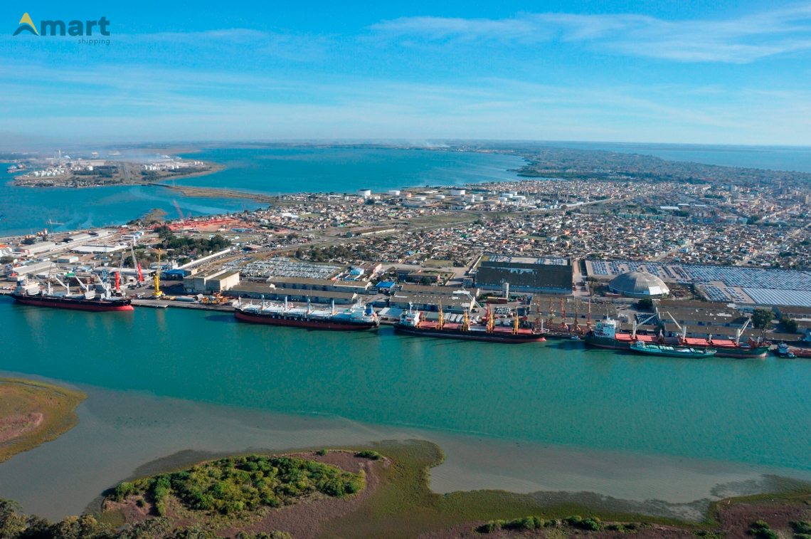
Port of
Porto Alegre
The port of Port Alegre, despite having river features, is classified as a seaport and it has operating capacity of up to 3 long-haul ships simultaneously.
Historical Facts
The port of Port Alegre, despite having river features, is classified as a seaport, as Resolution No. 2969 -ANTAQ of 4 July 2013. It maintains eight kilometers of wharf, divided between the Mauá Pier, Navegantes and Marcilio Dias. Its structure involves 25 stores with 70 thousand square meters, a total area 450 thousand square meters. Since the first half of 2005, the area of operation of public port is concentrated in Navegantes pier, which is governed by international standards ISPS-CODE safety, since 2010.
It has operating capacity of up to 3 long-haul ships simultaneously. Since the end of 2012, the port of Capital participates in the program developed by the federal government, called Paperless Port - PSP, which concentrates all its port data, sharing them with consenting agencies (Federal Police, Federal Revenue, VIGIAGRO, ANVISA, Navy of Brazil, among others).
The port zoning of the state capital offers distinct areas for multipurpose terminals, grain, fertilizer and general cargo. Over the past five years, the port of Porto Alegre with the terminals Private moved about 6 million tons / year in products such as offshore mooring cables, fertilizer, salt, vegetables grains, electrical transformers and cellulose.
Detalhes
Extension of the wharf: 8.028m (Mauá wharf: 3.240m - Navegantes wharf: 3.268m - Marcílio Dias wharf: 1.413m)
Berths: 33
Source: Official website of the Port of Porto Alegre